Metropolitan Area Outer Underground Discharge Channel
Underground water infrastructure project in Kasukabe, Saitama prefecture, Japan
You can help expand this article with text translated from the corresponding article in Japanese. (January 2022) Click [show] for important translation instructions.
- View a machine-translated version of the Japanese article.
- Machine translation, like DeepL or Google Translate, is a useful starting point for translations, but translators must revise errors as necessary and confirm that the translation is accurate, rather than simply copy-pasting machine-translated text into the English Wikipedia.
- Do not translate text that appears unreliable or low-quality. If possible, verify the text with references provided in the foreign-language article.
- You must provide copyright attribution in the edit summary accompanying your translation by providing an interlanguage link to the source of your translation. A model attribution edit summary is
Content in this edit is translated from the existing Japanese Wikipedia article at [[:ja:首都圏外郭放水路]]; see its history for attribution. - You may also add the template
{{Translated|ja|首都圏外郭放水路}}to the talk page. - For more guidance, see Wikipedia:Translation.
The Metropolitan Area Outer Underground Discharge Channel (Japanese: 首都圏外郭放水路, Hepburn: shutoken gaikaku hōsuiro), popularly known as G-Cans, is an underground water infrastructure project in Kasukabe, Saitama, Japan. It is the world's largest underground flood water diversion facility, built to mitigate overflowing of the city's major waterways and rivers during rain and typhoon seasons.[1] It is located between Showa and Kasukabe in Saitama prefecture, on the outskirts of the city of Tokyo in the Greater Tokyo Area.
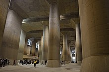
Work on the project started in 1992 and was completed by early 2006.[2][3] It consists of five concrete containment silos with heights of 65 metres (213 ft) and diameters of 32 metres (105 ft), connected by 6.4 kilometres (4.0 mi) of tunnels, 50 metres (160 ft) beneath the surface, as well as a large water tank with a height of 25.4 metres (83 ft), with a length of 177 metres (581 ft), with a width of 78 metres (256 ft), and with fifty-nine massive pillars connected to seventy-eight 10 MW (13,000 hp) pumps that can pump up to 200 metric tons (200 long tons; 220 short tons) of water into the Edo River per second.[4]

See also
- Tunnel and Reservoir Plan (in Chicago)
- Basilica Cistern (in Istanbul)
- Underground Construction
- Stormwater
- Sewerage
References
- ^ Sheer, Jon (n.d.). "Metropolitan Area Outer Underground Discharge Channel". AFAR. ISSN 1947-4377. OCLC 1054388800. Archived from the original on 22 April 2021. Retrieved 11 May 2022.
- ^ Zolbert, Alex (1 November 2012). "How giant tunnels protect Tokyo from flood threat". CNN. Tokyo. Archived from the original on 8 March 2022. Retrieved 11 May 2022.
- ^ "G-Cans: Tokyo's Massive Underground Storm Drain".
- ^ "G-Cans Project, Kasukabe, Saitama, Greater Tokyo Area, Japan". Retrieved 10 January 2015.
Wikimedia Commons has media related to Metropolitan Area Outer Underground Discharge Channel.
External links
- Official website (including photos) (in Japanese)
- v
- t
- e
Subterranea
| Types |
|
|---|---|
| Exemplars |
| Types | |
|---|---|
| Exemplars |
|
- American Society of Reclamation Sciences
- Bergamt
- Cave Research Foundation
- History of hard rock miners' organizations
- National Mine Map Repository
- National Mining Association
- National Speleological Society
- Grotto
- Institute of Materials, Minerals and Mining
- Institution of Mining Engineers
- International Union of Speleology
- Research Centre for Deep Drilling
- Society of Economic Geologists
- Southern African Institute of Mining and Metallurgy
35°59′51″N 139°48′42″E / 35.99750°N 139.81167°E / 35.99750; 139.81167


