Rila, Bulgaria
Town in Kyustendil, Bulgaria
Rila Рила | |
|---|---|
Town | |
| 42°08′N 23°08′E / 42.133°N 23.133°E / 42.133; 23.133 | |
| Country | Bulgaria |
| Province (Oblast) | Kyustendil |
| Municipality | Rila |
| Government | |
| • Mayor | Georgi Kabzimalski |
| Elevation | 593 m (1,946 ft) |
| Population (2008)[1] | |
| • Total | 3,044 |
| Time zone | UTC+2 (EET) |
| • Summer (DST) | UTC+3 (EEST) |
| Postal Code | 2630 |
| Area code | 07054 |


Rila (Bulgarian: Рила, pronounced [ˈriɫɐ]) is a town in southwestern Bulgaria, the administrative centre of Rila Municipality, in the southeastern part of Kyustendil Province.
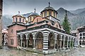
The town lies in a mountainous region at the foot of the southwestern Rila Mountains, 20 km (12 mi) from the Rila Monastery, 34 km (21 mi) from Dupnitsa, and 65 km (40 mi) from Kyustendil. It is situated on the banks of the Rilska River at the entrance of the Rila Monastery Nature Park. In antiquity, the area was inhabited by the Thracians and Romans; it was known as Sportela and then as Roligera. In the Middle Ages it was part of the Bulgarian Empire. In the 14th century, the village was a feudal possession of the Rila Monastery and may have been mentioned in Tsar Ivan Shishman of Bulgaria's Rila Charter as Driska. Later on, it was mentioned as İrlie in Ottoman tax registers of 1576.
- v
- t
- e

- Sofia (capital)

- Balchik
- Bankya
- Berkovitsa
- Byala Slatina
- Cherven Bryag
- Chirpan
- Elhovo
- Etropole
- Gotse Delchev
- Harmanli
- Ihtiman
- Karnobat
- Kavarna
- Knezha
- Kostinbrod
- Kozloduy
- Mezdra
- Nesebar
- Novi Iskar
- Novi Pazar
- Panagyurishte
- Parvomay
- Pavlikeni
- Peshtera
- Pomorie
- Popovo
- Provadia
- Radnevo
- Radomir
- Rakovski
- Razlog
- Stamboliyski
- Svilengrad
- Aksakovo
- Bansko
- Belene
- Belogradchik
- Beloslav
- Bobov Dol
- Bozhurishte
- Byala, Ruse Province
- Chepelare
- Devin
- Devnya
- Dolni Chiflik
- Dryanovo
- Dulovo
- Elena
- Elin Pelin
- Galabovo
- General Toshevo
- Hisarya
- Isperih
- Kostenets
- Kotel
- Krichim
- Krumovgrad
- Kubrat
- Kuklen
- Levski
- Lukovit
- Lyaskovets
- Lyubimets
- Madan
- Momchilgrad
- Omurtag
- Oryahovo
- Perushtitsa
- Pirdop
- Rakitovo
- Saedinenie
- Septemvri
- Simeonovgrad
- Simitli
- Slivnitsa
- Sopot, Plovdiv Province
- Sredets
- Straldzha
- Svoge
- Tervel
- Teteven
- Topolovgrad
- Tryavna
- Tsarevo
- Tutrakan
- Tvarditsa
- Varshets
- Veliki Preslav
- Yakoruda
- Zlatitsa
- Zlatograd
- Aheloy
- Apriltsi
- Ardino
- Banya
- Batak
- Batanovtsi
- Belitsa
- Belovo
- Borovo
- Bratsigovo
- Bregovo
- Breznik
- Byala
- Chernomorets
- Dalgopol
- Debelets
- Dobrinishte
- Dolna Banya
- Dolna Mitropoliya
- Dolna Oryahovitsa
- Dolni Dabnik
- Dospat
- Dragoman
- Dunavtsi
- Dve Mogili
- Dzhebel
- Glodzhevo
- Godech
- Gulyantsi
- Gurkovo
- Hadzhidimovo
- Ignatievo*
- Iskar
- Ivaylovgrad
- Kableshkovo
- Kalofer
- Kameno
- Kaspichan
- Kilifarevo
- Klisura
- Kocherinovo
- Koprivshtitsa
- Kostandovo
- Koynare
- Kresna
- Kran
- Krivodol
- Kula
- Laki
- Letnitsa
- Loznitsa
- Maglizh
- Malko Tarnovo
- Marten
- Мizia
- Nedelino
- Nikolaevo
- Nikopol
- Obzor
- Opaka
- Pavel Banya
- Polski Trambesh
- Pordim
- Pravets
- Primorsko
- Rila
- Roman
- Rudozem
- Sadovo
- Sapareva Banya
- Sarnitsa
- Shabla
- Shivachevo
- Slavyanovo
- Slivo Pole
- Smyadovo
- Sozopol
- Strazhitsa
- Strelcha
- Sungurlare
- Suvorovo
- Sveti Vlas
- Tran
- Trastenik
- Tsar Kaloyan
- Ugarchin
- Valchedram
- Valchi Dol
- Varbitsa
- Vetovo
- Vetren
- Yablanitsa
- Zavet
- Zlataritsa
- city status after the census of 01.02.2011: Ignatievo, Kran
| ||
|---|---|---|
Capital: Rila | ||
| Villages |
|  |
| Landmarks | ||
| Culture |
| |
| Notable people |
| |
Authority control databases | |
|---|---|
| International |
|
| National |
|
| Geographic |
|
 | This Kyustendil Province, Bulgaria location article is a stub. You can help Wikipedia by expanding it. |
- v
- t
- e


