National Register of Historic Places listings in Anderson County, South Carolina

This is a list of the National Register of Historic Places listings in Anderson County, South Carolina.
This is intended to be a complete list of the properties and districts on the National Register of Historic Places in Anderson County, South Carolina, United States. The locations of National Register properties and districts for which the latitude and longitude coordinates are included below, may be seen in a map.[1]
There are 24 properties and districts listed on the National Register in the county. Another 2 properties were once listed but have been removed.
This National Park Service list is complete through NPS recent listings posted June 21, 2024.[2]
Map all coordinates using OpenStreetMap
Download coordinates as:
- KML
- GPX (all coordinates)
- GPX (primary coordinates)
- GPX (secondary coordinates)
Current listings
| [3] | Name on the Register[4] | Image | Date listed[5] | Location | City or town | Description |
|---|---|---|---|---|---|---|
| 1 | Anderson College Historic District |  | May 20, 1998 (#98000556) | 316 Boulevard Ave. 34°30′49″N 82°38′18″W / 34.513611°N 82.638333°W / 34.513611; -82.638333 (Anderson College Historic District) | Anderson | |
| 2 | Anderson Downtown Historic District | 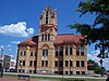 | February 23, 1979 (#79002372) | Main St. between Tribble and Market Sts.; also 402 N. Main St.; also 400-420 S Main & 109 W Market Sts. 34°29′50″N 82°38′59″W / 34.497222°N 82.649722°W / 34.497222; -82.649722 (Anderson Downtown Historic District) | Anderson | Additional addresses represent boundary increases approved November 5, 2007 and May 24, 2018 |
| 3 | Anderson Historic District |  | December 13, 1971 (#71000739) | Bounded by Hampton, Main, Franklin, McDuffie, Benson, and Fant Sts. 34°30′00″N 82°38′52″W / 34.5°N 82.647778°W / 34.5; -82.647778 (Anderson Historic District) | Anderson | |
| 4 | Ashtabula |  | March 23, 1972 (#72001186) | 1.25 miles northeast of Pendleton off South Carolina Highway 88 34°40′44″N 82°45′25″W / 34.678889°N 82.756944°W / 34.678889; -82.756944 (Ashtabula) | Pendleton | |
| 5 | Belton Depot | 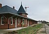 | August 13, 1979 (#79002373) | Public Square 34°31′21″N 82°29′41″W / 34.5225°N 82.494722°W / 34.5225; -82.494722 (Belton Depot) | Belton | |
| 6 | Belton Standpipe |  | November 5, 1987 (#87001948) | McGee St. 34°31′21″N 82°29′30″W / 34.5225°N 82.491667°W / 34.5225; -82.491667 (Belton Standpipe) | Belton | |
| 7 | Boone-Douthit House | 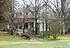 | July 3, 1997 (#97000742) | 1000 Milwee Creek Rd. 34°36′21″N 82°43′50″W / 34.605833°N 82.730556°W / 34.605833; -82.730556 (Boone-Douthit House) | Pendleton | |
| 8 | Caldwell-Johnson-Morris Cottage |  | October 7, 1971 (#71000740) | 220 E. Morris St. 34°29′55″N 82°38′50″W / 34.498611°N 82.647222°W / 34.498611; -82.647222 (Caldwell-Johnson-Morris Cottage) | Anderson | |
| 9 | Chamberlain-Kay House |  | November 25, 1980 (#80003652) | 205 River St. 34°31′26″N 82°29′29″W / 34.523889°N 82.491389°W / 34.523889; -82.491389 (Chamberlain-Kay House) | Belton | |
| 10 | Denver Downs Farmstead |  | March 7, 2007 (#07000118) | 4915 Clemson Boulevard 34°34′48″N 82°43′28″W / 34.580039°N 82.724317°W / 34.580039; -82.724317 (Denver Downs Farmstead) | Anderson | |
| 11 | Faith Cabin Library at Anderson County Training School |  | November 14, 2012 (#12000941) | 145 Town St. 34°39′08″N 82°47′16″W / 34.652106°N 82.787647°W / 34.652106; -82.787647 (Faith Cabin Library at Anderson County Training School) | Pendleton | Part of the Faith Cabin Libraries in South Carolina 1932-ca.1960 MPS |
| 12 | Robert J. and Lula Ginn House | 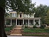 | September 23, 2019 (#100004408) | 106 Webb St. 34°30′07″N 82°39′37″W / 34.5020°N 82.6604°W / 34.5020; -82.6604 (Robert J. and Lula Ginn House) | Anderson | |
| 13 | Kennedy Street School |  | October 24, 2007 (#07001111) | 816 Kennedy St. 34°29′54″N 82°38′34″W / 34.498333°N 82.642778°W / 34.498333; -82.642778 (Kennedy Street School) | Anderson | |
| 14 | North Anderson Historic District | 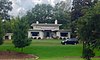 | July 31, 2008 (#08000733) | E. and W. North Ave. between Boundary St. and Mauldin Dr., including parts of Edgewood Dr., Blair St., and Central Ave. 34°31′16″N 82°39′30″W / 34.521143°N 82.658347°W / 34.521143; -82.658347 (North Anderson Historic District) | Anderson | |
| 15 | Dr. Samuel Marshall Orr House |  | April 13, 1973 (#73001673) | 809 W. Market St. 34°30′00″N 82°39′39″W / 34.5°N 82.660833°W / 34.5; -82.660833 (Dr. Samuel Marshall Orr House) | Anderson | |
| 16 | Pelzer Manufacturing Company and Mill Village Historic District |  | October 10, 2017 (#100001718) | Portions of Lebby, Reed, Courtney, Smythe, & Anderson Sts. 34°38′30″N 82°27′25″W / 34.641777°N 82.456928°W / 34.641777; -82.456928 (Pelzer Manufacturing Company and Mill Village Historic District) | Pelzer | |
| 17 | Pelzer Presbyterian Church | 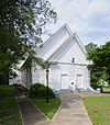 | December 13, 1993 (#93001407) | 13 Lebby St. 34°38′32″N 82°27′34″W / 34.642222°N 82.459444°W / 34.642222; -82.459444 (Pelzer Presbyterian Church) | Pelzer | |
| 18 | Pendleton Cotton Mill | 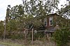 | January 29, 2018 (#100002060) | 250 S. Depot St. 34°38′48″N 82°46′42″W / 34.646667°N 82.778333°W / 34.646667; -82.778333 (Pendleton Cotton Mill) | Pendleton | |
| 19 | Pendleton Historic District |  | August 25, 1970 (#70000560) | Bounded on the west by Hopewell and Treaty Oak, on the north by Old Stone Church, on the east by Montpelier, and on the south by the town limits 34°39′40″N 82°47′42″W / 34.661111°N 82.795000°W / 34.661111; -82.795000 (Pendleton Historic District) | Pendleton | Extends into Oconee and Pickens counties |
| 20 | Ralph John Ramer House | 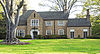 | February 10, 1992 (#92000023) | 402 Boulevard 34°30′49″N 82°38′27″W / 34.513611°N 82.640833°W / 34.513611; -82.640833 (Ralph John Ramer House) | Anderson | |
| 21 | Obediah Shirley House |  | September 3, 1999 (#99000201) | Bagwell Rd. 34°27′07″N 82°24′50″W / 34.451944°N 82.413889°W / 34.451944; -82.413889 (Obediah Shirley House) | Honea Path | |
| 22 | United States Post Office and Court House | 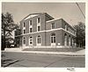 | October 13, 2017 (#100001746) | 315 S. McDuffie St. 34°30′07″N 82°38′54″W / 34.501928°N 82.648225°W / 34.501928; -82.648225 (United States Post Office and Court House) | Anderson | Now called the G. Ross Anderson, Jr. Federal Building and U.S. Courthouse. |
| 23 | Woodburn |  | May 6, 1971 (#71000741) | End of Woodburn Rd., west of Pendleton 34°38′26″N 82°47′47″W / 34.640556°N 82.796389°W / 34.640556; -82.796389 (Woodburn) | Pendleton | |
| 24 | Woodson Farmstead | Upload image | April 30, 1998 (#98000422) | 3 Powdersville Rd. 34°47′20″N 82°29′08″W / 34.788825°N 82.485658°W / 34.788825; -82.485658 (Woodson Farmstead) | Greenville | Farmstead was demolished in 2011. |
Former listings
| [3] | Name on the Register | Image | Date listed | Date removed | Location | City or town | Description |
|---|---|---|---|---|---|---|---|
| 1 | McFall House | Upload image | June 28, 1982 (#82003829) | December 8, 2005 | SR 247 34°26′40″N 82°35′40″W / 34.4444°N 82.5944°W / 34.4444; -82.5944 (McFall House) | Anderson vicinity | No longer exists.[6] |
| 2 | Nick Prevost House |  | July 10, 1984 (#84002020) | December 8, 2005 | 105 N. Prevost Street 34°30′05″N 82°40′32″W / 34.5014°N 82.6756°W / 34.5014; -82.6756 (Nick Prevost House) | Anderson | No longer exists.[7] |
See also
Wikimedia Commons has media related to National Register of Historic Places in Anderson County, South Carolina.
- List of National Historic Landmarks in South Carolina
- National Register of Historic Places listings in South Carolina
References
- ^ The latitude and longitude information provided in this table was derived originally from the National Register Information System, which has been found to be fairly accurate for about 99% of listings. Some locations in this table may have been corrected to current GPS standards.
- ^ National Park Service, United States Department of the Interior, "National Register of Historic Places: Weekly List Actions", retrieved June 21, 2024.
- ^ a b Numbers represent an alphabetical ordering by significant words. Various colorings, defined here, differentiate National Historic Landmarks and historic districts from other NRHP buildings, structures, sites or objects.
- ^ "National Register Information System". National Register of Historic Places. National Park Service. March 13, 2009.
- ^ The eight-digit number below each date is the number assigned to each location in the National Register Information System database, which can be viewed by clicking the number.
- ^ South Carolina Department of Archives and History
- ^ South Carolina Department of Archives and History
- v
- t
- e

by county
- Abbeville
- Aiken
- Allendale
- Anderson
- Bamberg
- Barnwell
- Beaufort
- Berkeley
- Calhoun
- Charleston
- Cherokee
- Chester
- Chesterfield
- Clarendon
- Colleton
- Darlington
- Dillon
- Dorchester
- Edgefield
- Fairfield
- Florence
- Georgetown
- Greenville
- Greenwood
- Hampton
- Horry
- Jasper
- Kershaw
- Lancaster
- Laurens
- Lee
- Lexington
- Marion
- Marlboro
- McCormick
- Newberry
- Oconee
- Orangeburg
- Pickens
- Richland
- Saluda
- Spartanburg
- Sumter
- Union
- Williamsburg
- York
Municipalities and communities of Anderson County, South Carolina, United States | ||
|---|---|---|
County seat: Anderson | ||
| Cities |  | |
| Towns | ||
| CDPs | ||
| Other communities | ||
| Footnotes | ‡This populated place also has portions in an adjacent county or counties | |
| ||


