National Register of Historic Places listings in Orangeburg County, South Carolina

This is a list of the National Register of Historic Places listings in Orangeburg County, South Carolina.
This is intended to be a complete list of the properties and districts on the National Register of Historic Places in Orangeburg County, South Carolina, United States. The locations of National Register properties and districts for which the latitude and longitude coordinates are included below, may be seen in a map.[1]
There are 42 properties and districts listed on the National Register in the county. Another 2 properties were once listed but have been removed.
This National Park Service list is complete through NPS recent listings posted June 7, 2024.[2]
Map all coordinates using OpenStreetMap
Download coordinates as:
- KML
- GPX (all coordinates)
- GPX (primary coordinates)
- GPX (secondary coordinates)
Current listings
| [3] | Name on the Register[4] | Image | Date listed[5] | Location | City or town | Description |
|---|---|---|---|---|---|---|
| 1 | All Star Bowling Lane |  | August 7, 1996 (#96000837) | 559 E. Russell St. 33°29′34″N 80°51′34″W / 33.4929°N 80.859515°W / 33.4929; -80.859515 (All Star Bowling Lane) | Orangeburg | Protest against the bowling center's segregationist policy in 1968 led to the Orangeburg massacre in which 3 were killed |
| 2 | Amelia Street Historic District | Upload image | September 20, 1985 (#85002322) | Amelia St. between Treadwell St. and Summers Ave. 33°29′39″N 80°51′37″W / 33.494167°N 80.860278°W / 33.494167; -80.860278 (Amelia Street Historic District) | Orangeburg | |
| 3 | F.H.W. Briggman House |  | September 20, 1985 (#85002337) | 156 Amelia St. 33°29′25″N 80°51′56″W / 33.490261°N 80.865601°W / 33.490261; -80.865601 (F.H.W. Briggman House) | Orangeburg | |
| 4 | Donald Bruce House |  | December 1, 1978 (#78002528) | Southeast of Orangeburg on U.S. Route 301 33°28′36″N 80°48′53″W / 33.476667°N 80.814722°W / 33.476667; -80.814722 (Donald Bruce House) | Orangeburg | |
| 5 | Cattle Creek Campground | Upload image | May 19, 1983 (#83002204) | Off South Carolina Highway 210 33°19′20″N 80°45′08″W / 33.322222°N 80.752222°W / 33.322222; -80.752222 (Cattle Creek Campground) | Rowesville | |
| 6 | Claflin College Historic District |  | September 20, 1985 (#85002324) | On a portion of the Claflin College campus 33°29′51″N 80°51′18″W / 33.4975°N 80.855°W / 33.4975; -80.855 (Claflin College Historic District) | Orangeburg | |
| 7 | Cope Depot | 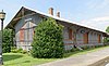 | March 29, 2001 (#01000298) | Cope Rd. 33°22′40″N 81°00′28″W / 33.37775°N 81.00772°W / 33.37775; -81.00772 (Cope Depot) | Cope | |
| 8 | Dantzler Plantation | Upload image | March 1, 2007 (#07000098) | 2755 Vance Rd. 33°24′56″N 80°30′23″W / 33.415608°N 80.506383°W / 33.415608; -80.506383 (Dantzler Plantation) | Holly Hill | |
| 9 | Dixie Library Building | 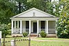 | September 20, 1985 (#85002336) | Corner of Bull and Middleton Sts.[6] 33°29′33″N 80°52′05″W / 33.49259°N 80.86806°W / 33.49259; -80.86806 (Dixie Library Building) | Orangeburg | |
| 10 | Dukes Gymnasium |  | September 20, 1985 (#85002321) | South Carolina State University campus 33°29′50″N 80°51′01″W / 33.497326°N 80.850374°W / 33.497326; -80.850374 (Dukes Gymnasium) | Orangeburg | |
| 11 | East Russell Street Area Historic District | Upload image | September 20, 1985 (#85002335) | Along sections of E. Russell St. between Watson and Clarendon Sts., and along portions of Oakland Pl. and Dickson and Whitman Sts. 33°29′36″N 80°51′04″W / 33.493333°N 80.851111°W / 33.493333; -80.851111 (East Russell Street Area Historic District) | Orangeburg | |
| 12 | Ellis Avenue Historic District | Upload image | September 20, 1985 (#85002327) | Along portions of Ellis Ave. between Summers Ave. and Wilson St. 33°29′53″N 80°51′47″W / 33.498056°N 80.863056°W / 33.498056; -80.863056 (Ellis Avenue Historic District) | Orangeburg | |
| 13 | Enterprise Cotton Mills Building |  | September 20, 1985 (#85002340) | U.S. Route 21 33°29′14″N 80°51′14″W / 33.487161°N 80.853977°W / 33.487161; -80.853977 (Enterprise Cotton Mills Building) | Orangeburg | |
| 14 | Eutaw Springs Battleground Park |  | June 5, 1970 (#70000593) | 2 miles east of Eutawville on South Carolina Highways 6 and 45 33°24′30″N 80°17′57″W / 33.408333°N 80.299167°W / 33.408333; -80.299167 (Eutaw Springs Battleground Park) | Eutawville | |
| 15 | Maj. John Hammond Fordham House |  | September 20, 1985 (#85002341) | 415 Boulevard 33°29′58″N 80°51′20″W / 33.499444°N 80.855556°W / 33.499444; -80.855556 (Maj. John Hammond Fordham House) | Orangeburg | |
| 16 | Great Branch Teacherage |  | October 24, 2007 (#07001112) | 2890 Neeses Highway 33°31′20″N 81°00′13″W / 33.522244°N 81.0036°W / 33.522244; -81.0036 (Great Branch Teacherage) | Orangeburg | |
| 17 | Hodge Hall | 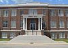 | September 20, 1985 (#85002320) | South Carolina State University campus 33°29′51″N 80°51′06″W / 33.497615°N 80.851643°W / 33.497615; -80.851643 (Hodge Hall) | Orangeburg | |
| 18 | Holly Hill Downtown Historic District | Upload image | January 9, 2024 (#100009752) | Portions of Gardner Blvd., Old State Road, and Railroad Ave. 33°19′17″N 80°24′41″W / 33.3214°N 80.4115°W / 33.3214; -80.4115 (Holly Hill Downtown Historic District) | Holly Hill | |
| 19 | Hotel Eutaw |  | September 20, 1985 (#85002318) | Russell and Centre Sts. 33°29′29″N 80°51′38″W / 33.491481°N 80.860511°W / 33.491481; -80.860511 (Hotel Eutaw) | Orangeburg | |
| 20 | Lowman Hall, South Carolina State College |  | September 20, 1985 (#85002346) | South Carolina State College campus 33°29′43″N 80°51′14″W / 33.495323°N 80.853790°W / 33.495323; -80.853790 (Lowman Hall, South Carolina State College) | Orangeburg | |
| 21 | Alan Mack Site (38OR67) | Upload image | January 6, 1986 (#86000044) | Address Restricted | Orangeburg | |
| 22 | McCoy Farmstead | Upload image | January 22, 2019 (#100003315) | 307 Boyer Rd. 33°19′05″N 80°26′05″W / 33.3180°N 80.4348°W / 33.3180; -80.4348 (McCoy Farmstead) | Holly Hill | |
| 23 | Mt. Pisgah Baptist Church |  | September 20, 1985 (#85002342) | 310 Green 33°29′34″N 80°51′55″W / 33.492891°N 80.865154°W / 33.492891; -80.865154 (Mt. Pisgah Baptist Church) | Orangeburg | |
| 24 | Numertia Plantation |  | March 19, 1982 (#82003898) | East of Eutawville 33°23′00″N 80°16′51″W / 33.383333°N 80.280833°W / 33.383333; -80.280833 (Numertia Plantation) | Eutawville | |
| 25 | Orangeburg City Cemetery |  | September 27, 1996 (#96001025) | Junction of Bull and Windsor Sts. 33°29′21″N 80°52′15″W / 33.489154°N 80.870756°W / 33.489154; -80.870756 (Orangeburg City Cemetery) | Orangeburg | |
| 26 | Orangeburg County Fair Main Exhibit Building |  | September 20, 1985 (#85002344) | U.S. Route 21 33°28′49″N 80°51′10″W / 33.480274°N 80.852768°W / 33.480274; -80.852768 (Orangeburg County Fair Main Exhibit Building) | Orangeburg | |
| 27 | Orangeburg County Jail |  | October 2, 1973 (#73001724) | 44 Saint John St. 33°29′22″N 80°51′42″W / 33.489540°N 80.861552°W / 33.489540; -80.861552 (Orangeburg County Jail) | Orangeburg | |
| 28 | Orangeburg Downtown Historic District |  | September 20, 1985 (#85002317) | Russell, Broughton, Middleton, Church, Meeting, St. John, Hampton, and Amelia Sts. around the public square 33°29′24″N 80°51′49″W / 33.49°N 80.863611°W / 33.49; -80.863611 (Orangeburg Downtown Historic District) | Orangeburg | |
| 29 | Providence Methodist Church |  | September 25, 2009 (#08001395) | 4833 Old State Rd. 33°23′33″N 80°32′26″W / 33.392529°N 80.540493°W / 33.392529; -80.540493 (Providence Methodist Church) | Holly Hill | |
| 30 | St. Julien Plantation | Upload image | November 28, 1980 (#80003693) | South Carolina Highway 6 33°24′35″N 80°21′11″W / 33.409722°N 80.353056°W / 33.409722; -80.353056 (St. Julien Plantation) | Eutawville | |
| 31 | South Carolina State College Historic District | Upload image | June 19, 1997 (#96001024) | 300 College St. 33°29′46″N 80°51′11″W / 33.496111°N 80.853056°W / 33.496111; -80.853056 (South Carolina State College Historic District) | Orangeburg | |
| 32 | Southern Railway Passenger Depot |  | April 23, 1973 (#73001723) | 110 N. Main St. 33°15′04″N 80°48′57″W / 33.251111°N 80.815833°W / 33.251111; -80.815833 (Southern Railway Passenger Depot) | Branchville | |
| 33 | Springfield High School | 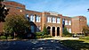 | March 29, 2001 (#01000313) | Brodie St., between South Carolina Highway 4 and Georgia St. 33°29′44″N 81°16′27″W / 33.495556°N 81.274167°W / 33.495556; -81.274167 (Springfield High School) | Springfield | |
| 34 | William P. Stroman House |  | August 1, 1996 (#96000836) | 1017 N. Boulevard 33°30′13″N 80°51′34″W / 33.50360°N 80.85951°W / 33.50360; -80.85951 (William P. Stroman House) | Orangeburg | |
| 35 | Tingley Memorial Hall, Claflin College |  | August 4, 1983 (#83002205) | College Ave. 33°29′54″N 80°51′16″W / 33.498414°N 80.854333°W / 33.498414; -80.854333 (Tingley Memorial Hall, Claflin College) | Orangeburg | |
| 36 | Treadwell Street Historic District | Upload image | September 20, 1985 (#85002315) | Along portions of Treadwell and Amelia Sts. 33°29′45″N 80°51′30″W / 33.495833°N 80.858333°W / 33.495833; -80.858333 (Treadwell Street Historic District) | Orangeburg | |
| 37 | Trinity Lutheran Church | 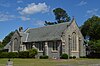 | August 1, 2008 (#08000721) | 390 Hampton St. 33°31′59″N 80°34′17″W / 33.533014°N 80.571467°W / 33.533014; -80.571467 (Trinity Lutheran Church) | Elloree | |
| 38 | Trinity Methodist Episcopal Church |  | August 26, 1994 (#94001053) | 185 Boulevard NE. 33°29′44″N 80°51′23″W / 33.495569°N 80.856505°W / 33.495569; -80.856505 (Trinity Methodist Episcopal Church) | Orangeburg | |
| 39 | White House United Methodist Church |  | May 13, 1974 (#74001872) | Near intersection of U.S. Highway 301 and Interstate 26[7] 33°27′35″N 80°43′05″W / 33.459763°N 80.718082°W / 33.459763; -80.718082 (White House United Methodist Church) | Orangeburg | |
| 40 | Whitman Street Area Historic District | Upload image | September 20, 1985 (#85002326) | Along sections of Whitman, Elliot, and E. Russell Sts. 33°29′28″N 80°51′29″W / 33.491111°N 80.858056°W / 33.491111; -80.858056 (Whitman Street Area Historic District) | Orangeburg | |
| 41 | Williams Chapel A.M.E. Church | 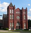 | September 20, 1985 (#85002345) | 1198 Glover St.[8] 33°29′11″N 80°51′38″W / 33.486266°N 80.860517°W / 33.486266; -80.860517 (Williams Chapel A.M.E. Church) | Orangeburg | |
| 42 | Willow Consolidated High School |  | July 11, 2006 (#06000581) | 2750 Cope Rd. 33°26′46″N 81°07′23″W / 33.44611°N 81.12300°W / 33.44611; -81.12300 (Willow Consolidated High School) | Norway |
Former listings
| [3] | Name on the Register | Image | Date listed | Date removed | Location | City or town | Description |
|---|---|---|---|---|---|---|---|
| 1 | Gilmore House | Upload image | September 19, 1988 (#88001470) | December 8, 2005 | State St. & Eutaw Rd. | Holly Hill | Demolished[9] |
| 2 | Rocks Plantation |  | July 13, 1976 (#76001709) | March 15, 2005 | Near SC Highway 6 | Eutawville | Destroyed by fire in March, 1992.[10][11] |
See also
Wikimedia Commons has media related to National Register of Historic Places in Orangeburg County, South Carolina.
- List of National Historic Landmarks in South Carolina
- National Register of Historic Places listings in South Carolina
References
- ^ The latitude and longitude information provided in this table was derived originally from the National Register Information System, which has been found to be fairly accurate for about 99% of listings. Some locations in this table may have been corrected to current GPS standards.
- ^ National Park Service, United States Department of the Interior, "National Register of Historic Places: Weekly List Actions", retrieved June 7, 2024.
- ^ a b Numbers represent an alphabetical ordering by significant words. Various colorings, defined here, differentiate National Historic Landmarks and historic districts from other NRHP buildings, structures, sites or objects.
- ^ "National Register Information System". National Register of Historic Places. National Park Service. March 13, 2009.
- ^ The eight-digit number below each date is the number assigned to each location in the National Register Information System database, which can be viewed by clicking the number.
- ^ "Orangeburg, a Small Town with a Big History"; walking-tour brochure. Retrieved 2015-04-28.
- ^ "National Register of Historic Places Inventory—Nomination Form: White House United Methodist Church". South Carolina Department of Archives and History. Retrieved 2015-04-27.
- ^ "Get Connected" (Williams Chapel website). Retrieved 2015-05-01.
- ^ "SCDAH".
- ^ "Fire claims Hugo survivor". The Times and Democrat. March 20, 1992. p. 2B. Retrieved August 24, 2022 – via Newspapers.com.
- ^ "SCDAH".
- v
- t
- e

by county
- Abbeville
- Aiken
- Allendale
- Anderson
- Bamberg
- Barnwell
- Beaufort
- Berkeley
- Calhoun
- Charleston
- Cherokee
- Chester
- Chesterfield
- Clarendon
- Colleton
- Darlington
- Dillon
- Dorchester
- Edgefield
- Fairfield
- Florence
- Georgetown
- Greenville
- Greenwood
- Hampton
- Horry
- Jasper
- Kershaw
- Lancaster
- Laurens
- Lee
- Lexington
- Marion
- Marlboro
- McCormick
- Newberry
- Oconee
- Orangeburg
- Pickens
- Richland
- Saluda
- Spartanburg
- Sumter
- Union
- Williamsburg
- York


